Road trip

6 07 2021

As foreign travel is fraught with too much hassle I have decided to change direction in my geocaching. For several years I have had the aim of adding a new country to the list of those in which I have found caches. It will now be parked at forty eight for the foreseeable future. On the other hand Sweden has 21 counties to explore. I have actually found caches in all 21 counties but only in 179 boroughs meaning that I still have another 111 to go and considering Swedens geographical area it could take some time.

In 2012 I made a one day road trip to parts of Värmland and Örebro län that netted around twenty new boroughs. This time I decided to aim for the closest five boroughs where I needed to find a cache and came up with Vingåker, Finspång, Söderköping, Oxelösund and Gnesta. Google maps indicated it was around 800 km and would take the best part of ten hours without pauses. As it turned out the whole journey was 827 km and took 13:45 according to my GPS tracklog. As I am also a radio ham (remember Tony Hancock or Marve Fleksnes and you’ll get completely the wrong idea) I have an APRS tracker in my car so I can (among other things) see where my car has been (providing I switch my radio on).

DS8300 / SA3ARQ-9 Track log 20210703

So with coffee, food and water packed I set off just after 7 am so I wouldn’t need to worry too much about traffic for a few hours. Apart from a couple of very short pauses just to check something on my phone I arrived at The Big Apple also known as Vingåker, at around 10:30 . Vingåker is known for te Sävstaholm apple. It was good to stretch my legs.

The Big Apple,Vingåker

Just down the road I stopped again for Västra Vingåkers kyrka which was quickly retrieved. I didn’t have time to look at the church or the Hembygdsmuseum.

Museum of local culture, Vingåker

About the same distance again and I was in the centre of Vingåker where I grabbed Nedlagda Postkontor: Vingåker which is now a Coop and today was closed due to a cyber attack with ransomeware as the payload. ICA will be rubbing their hands as that seems to be the only other supermarket in the community.

VingåkerMainStreet

From Vingåker I left Södermanland and crossed over to Östergötaland and the outskirts of Finspång. I was quickly able to grab Finspångsnostalgi Panncentralen. It’s alway fun to visit old repurposed industry sites.

Finspång Old “Panncentral”

Just across the main E51 was a shopping outlet that has also seen better days with an almost deserted car park so grabbing Viberga was a simple operation.

Finspång Viberga shopping centre car park

Fom here I took the E51 and E4 to the Tornby shopping area in Linköping where I had an item to pick up. Once that was done I headed off to Söderköping and the Götakanal. I arrived there at 2 pm just in time to see a boat arrive at the sliding bridge. I knew time was not on my side so I started walking along the canal to pick up …pirum parum …, …kråkan satt…, …på en gren finding them all at good coordinates. So now after five hours I had found nine caches which isn’t a big number of course, but as planned.

Göta Kanal Vennerberga Bridge and boat waiting for it to open

I managed to get through Norrköping despite taking a wrong turn at the weird roundabout by the E22. To go west you need to drive East so I ended up driving right through Norrköping along Södra Promenaden where all the posh houses are. One was featured on a TV program not so long ago.

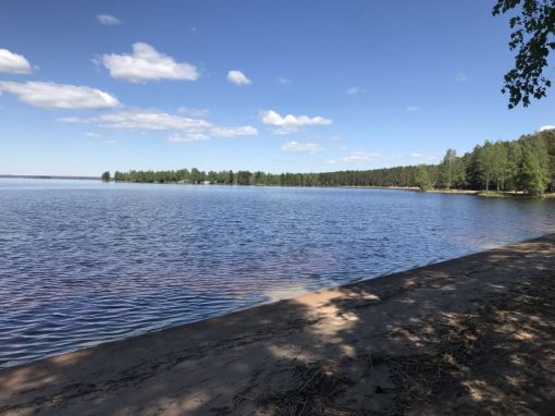
From there on my next target was Femöre in Oxelösund. I would have liked to visit the old cold war coastal artillery site ”Femörefortet” which is now a museum but I imagine it is pretty much like Arholma and Hemsö which I have visited and in addition I didn’t have time. I did have time to eat my lunch despite it being quarter to four in the afternoon.

Femöre Naturreservat

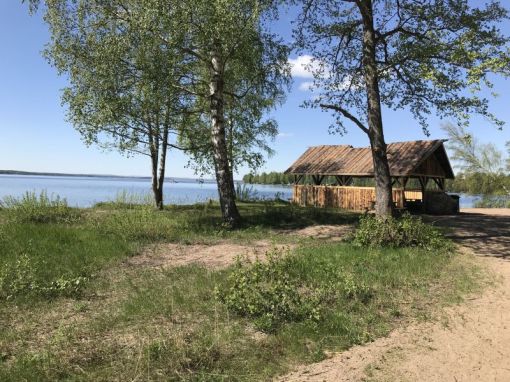
There were three caches all within a few hundred meters that suited my needs perfectl. I started with Välkommen till Femöre which was just behind me in the photo above. The other two were part of a D-bomb series of caches. Apparently many were released on the same day all over the county in 2017.

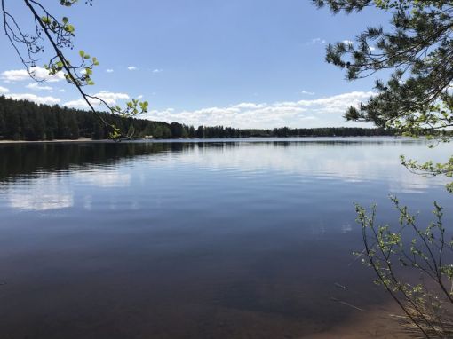
Femöre Utsikt from D-bomb #1
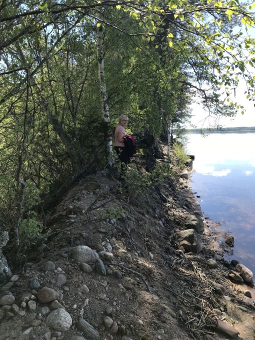
Femöre D-bomb #2

Petrol was the next item on the agenda so I pointed my car towards the first petrol sign in Nyköping only to find that their equipment wasn’t working. Luckily I found what I needed and could carry on towards Gnesta, the final borough for the day.

Welcome to Gnesta

It was also where I found two caches that were worth favourit points but for different reasons. Holk de lux was worth a point for it’s construction.

Holk De lux Gnesta. Really great construction

The second cache that got a fvourite point was because of the experience more than the cache itself. As the name suggests Gnesta Bryggeri cache was located near to the old brewery, now an arts centre. The cache was in the car park that was surrounded by a high fence. As I rounded the fence I surprised a woman who was picking flowers. We started talking and I said I was geocaching. Her reply was that she knew where the cache was. After a few hints she admitted that the cache was hers and pointed me to a spot I would probably not have found on my own. Snusmulle was the geocachers name. It’s always great to meet fellow geocachers.

GnestaBryggeri Tricky little blighter

From there it was just the three plus hour drive home to Gävle with a break for food and break just before Hjulsta Bron over Mälaren. All in all a great but tiring day and I found all the caches I had intended to find. Now I have to plan for my next road trip and hopefully it will be more efficient.


Hässlen and Realsbo

5 06 2021

The geocaching trail round a couple of small nature reserves called Hässlen and Realsbo has been on my todo list for a number of years (caches placed in 2015) but it was first now that I got around to actually visiting them.

HässlanNaturreservat

Hässlen and Realsbo nature reserves

Until the end of 2018 I was travelling abroad so often I didn’t have time to do any geocaching and in 2019 other things demanded my attention. Last year and most of this year have been times with very little movement but now the situation has improved.

On the way to Hässlen which lies just to the south of Garpenberg and west of Horndal I stopped at Malmjärn runt 54 and started the day with a DNF. Hmm.

We arrived at Hässlen and parked that car just as a farmer arrived with a trailer load of sheep that were to be put to graze in the reserve.

Får

That meant we couldn’t start to hunt for Berget runt #01. As it was time for coffee we found a suitable place to sit and ate our picnic. If possible on hot days I try to avoid carrying a rucksack. There was no need for extra clothing so we just took water with us and didn’t need a rucksack for that.

We passed through the field of hazel trees and made our way to Berget runt #02. I have never seen such an expanse of hazels before this far north in Sweden. Obviously as we were in a nature reserve we couldn’t pick them, not that there were any visible this early in the year. I’m sure the Nucifraga caryocatactes – spotted nutcracker (Nötkråka) are happy that they are there.

Hasselträd

Hazel trees at Hässlen

Although the trail passed through the usual pine forest it soon changed character and we were surrounded by majestic ash and silver birch trees. They formed part of the Realsbo nature reserve which is just south of Hässlen.

HässlenLövskog

Mighty ashes and silver birches

The next section was along gravel roads then a small MTB track back to the car park. By then we were ready for our second coffe and this time we could sit at the benches and table in the middle of the field near the house.

HässlenÄng

Buildings and meadow at Hässlen

My final cache in the area was Hässlen in which I dropped of a TB. I thought that Chip and Dale (Piff och Puff) would like the access to nuts!

HässlenPiffOPuff

Chip and Dale moving in to Hässlen

Once that was done I calculated the coords for https://coord.info/GC5R8JP Berget runt bonus which we found on our way back to the car.

Hässlen_Berget_runt_Done

Found geocaches

I had one more cache to find and that was Challenge#Logga 20 Svenska kommuner på ett dygn.
I met the requirements in 2012 but this was the first time I was close enough to the cache to log the find.

All in all a great day.

Dagens statistik
Caching: 30 icon_smile | 1 bluey | 1 📝
Körde: 211 km
Gick: 8,8 km
Vädret: +20-22° ☀️


Årsunda

28 05 2021

Winter is usually a time when my geocaching activities are either super high (trip to New Zealand for a month or so) or super low (stay at home in Sweden). This year due to the pandemic I had no choice but to stay home and as a consequence my find count at the end of March was three, yes t h r e e caches.

Now at the end of May things have started to look up but my activity level is still lower than usual. I blame it on the weather, or more likely the lethargy that a pandemic brings on you when you don’t really have the same freedom of movement everywhere that you are used to. I know, excuses. Just do it.

So I did. Bought a new GPS that is. My existing GPS is a Garmin Oregon 450 which I have had for several years now and it’s age was showing. The rubber cover on the on/off switch had gone and the touch screen was badly scratched. Otherwise it works perfectly and is a convenient size for my pocket. I have looked at a Garmin GPSMAP 64 series GPS since they came out but as I had a working GPS there was no reason to buy one. The larger size and smaller screen put me off a little. I remember the buttons on the Garmin eTrex GPSr’s that I have owned and found the touch screen to be convenient – most of the time. It didn’t like me wearing gloves and as mentioned above the protective layer soon wore off. I needed to find a replacement and after looking at the models that Garmin now has my choice finally fell on the GPSMAP 65s. I nearly sent it back as I felt that the screen was too small, but after using it I really liked the accuracy it has even under tree cover. I use my iPhone if I need to see satellite images of the area I am in and for logging in the field.

Oregon450vsGPSMAP65s

Garmin Oregon 450 & GPSMAP 65s

I have also learnt about the existence of Garmin Explore and the improved Basecamp software. I installed Basecamp a few years ago then removed it as the older and simpler Mapsource was more useful for what I needed to do. Let’s see if Basecamp has more to offer me this time. I see that I can sync the contents of my GPS with a Garmin site so that it can be shared and also saved on my phone. Again, I don’t see any need for this functionaility right now but something may turn up in the future.

So of course, I just grabbed the GPS, stuck in batteries and loaded the relevant OSM map and a .gpx file of geocaches around Årsunda and took it with me for a few hours of geocaching. No need to wonder how the thing worked, it just did.

When we got to Strandbaden in Årsunda it was time for our picnic which we ate sitting at a table near the campsite. This is where the difference between online and offline caching showed up. I had downloaded a relatively old pocket query imported into GSAK which I still find to be the best geocaching tool ever and transferred that to my GPS. My GPS showed Strandbaden to be just a few meters from where we were sitting but my phone with it’s simple geocaching app showed it to be over towards a little red building a hundred meters away. From experience I know that the online data is usually the latest so I didn’t even bother to look for the cache based on the GPS reading.

Strandbaden

Strandbaden

We then started to follow the beach around to Åshuvudet stopping first at Grillplats. My GPS sent me to a three trunked tree (the one to the left of the photo) several meters from the roofed grill area. Nothing.

Grillplats

Grillplats

A message was sent to SE81293 as he was the last to find the cache and only then with the help of a lifeline, but before we got a reply we had moved on to Tärnbräck2 and Tärnbräck.

Tärnbräck2

View from Tärnbräck 2

Tärnbräck2 was a simple find and the coordinates were fine. Tärnbräck on the other hand was way off. The coordinates I got were included in my log. I’m pretty sure that they are far more accurate than the ones posted.

The path out to Åshuvudet 3 and the other two caches we found before getting to the end of the peninsular was great fun especially when the peninsular narrowed down to being just over a meter wide.

Åshuvud3

Åshuvudet 3

We arrived back at ”Grillplats” after receiving a message from SE81293 with information on where to search for the cache. It was a good eight meters from the tree high up under the rof of the grill. Not unexpected of course, but not at the coordinates given.

This is where it doesn’t matter if you have a commercial grade GPS costing thousands that is garanteed to put you within a centimeter of a spot on the earth when the person posting coordinates, in this case a geocacher, has a piece of equipment that is not at all that accurate. Mobile phones of anything but the latest generation seem to come into that category. Nevermind, it’s part of the experience.

From Årsunda we drove over to Gammelstilla Bruk via Snart hemma? My cache at Gammelstilla is still in place after nine years so I’m happy with that. The day ended with a visit to Torsåkers Pelargonmuseum och Trädgård and the purchase of a couple of English geraniums – what else?

Dagens statistik
Caching: 8 
Körde: 114 km
Gick: 7,8 km
Vädret: +20-22°
☀️


First cache of the year and targets 2021

27 01 2021

Woke up and looked at the thermometer. -15.8°C ! Did I really want to go out and find the multicache I had stumbled over some clues to on my daily walk yesterday? I had contacted the CO to confirm an item and said I would find the cache today so I didn’t really have much choice.

The cache I refer to is Grindslanten and is a multi starting just beyond Brynäs school here in Gävle, not that I am sure that the school is in use any longer. Who knows these days?

My first visit to the starting point for the cache was probably some time last year ago even though I had passed by the spot several times since the cache was placed in 2017. My calcuations for the next WP coincided with an area where several EU-migrants had set up camp in old cars and vans so I didn’t fancy poking around there looking for clues. I forgot all about the cache until I walked past the WP yeserday. I needn’t have worried about disturbing people as the clues were very obvious and didn’t need any foraging in bushes to find them.

All the clues are in place but as I hadn’t been looking for clues I sent a mail to the CO with my suggestion for coords to the next WP. I was on track! Yes!

By noon the temperature was a balmy 8°C so we parked at an appropriate place and set off on foot towards the WP to count reflectors. I had calculated all the combinations of clues so in a worst case scenario I just had to visit nine or ten places. The reflectors were easily seen and there were no traces that any had been removed so off we went. Thirty meters from the cache I spotted the container. Nice! Appropriate for the area.

It’s as cold as it looks.

The photo has nothing to do with the cache but gives an indication of the weather we are now having. After weeks of grey cloudy weather this was a fine sunny day, albeit a little chilly.

So, having taken nearly a month of the year to find my first cache it’s time to talk about targets for 2021. I have had them in mind since the beginning of the year but not published them. My brother who is a fellow geocacher (Zelger) and I both have targets so there is a bit of friendly rivalry as to who is doing best. This year, he will not have any targets. He lives in England and is just recovering from a bout of Covid-19 with the expectation that the present lockdown will continue for quite some time in the year.

Even I have reduced my ambitions. No more finding a cache in a new country, so my result of 48 countries will not change for a while. The new search motor and filter on the geocaching web site makes setting targets easier so I have arrived at the folowing targets.

– Update my blog at least once a month.
– Complete round 2 of the D/T matrix.
– Complete round 3 of the D/T matrix.

Round 2 – red circles and round 3 – blue circles


– Find caches in ten more Swedish counties
– BadgeGen – upgrade Ruby Badges to Sappphire
– “The Traditional Cacher” – Trads (747)
– “The Mysterious Cacher” – Mysts (16)
– “The Virtual Cacher” – Virtual (4)
– “The Environmental Cacher” – CITO (1)
– “The Large Cacher” – Large (10)
– Place 5 caches.
– Complete the alphabetic mystery owner challenge GC44FDK Questionable COs: A-Z Roll of Honour Challenge: Q or U or W=1. (This is seemingly a never ending story).

Perhaps it will be easier to focus on the targets now that the tools to find them have improved. The only thing to note is that most of them havew both a high difficulty and terrain rating. Should be fun!


Follow up on 2020 targets

5 01 2021

As is usual I set myself geocaching targets for a calendar year. This post is just a follow up on how well I did in 2020. Geocaching Targets 2020

1. Update my blog more frequently!
The target was 12 posts and I published 12 post. OK.

2. Find a cache in one new country.
For obvious reasons foreign travel has been paused. Fail.

3. Complete round 2 of the D/T matrix (Jasmer challenge) – 8 combinations.
Eight combinations needed and one found. Fail.

4. BadgeGen – upgrade Ruby Badges to Sappphire
– “The Geocacher” – All geocaches (410) 418 found. OK.
– “The Traditional Cacher” – Trads (1033) 286 found. Fail.
– “The Mysterious Cacher” – Mysts (75) 59 found. Fail.
– “The Virtual Cacher” – Virtual (4) 0 found. Fail.
– “The Social Cacher” – Events (3) 7 attended. OK.
Interesting to note is that all were attended in the first quarter of the year – before the pandemic started.
– “The Environmental Cacher” – CITO (1) 0 found. Fail.
– “The Large Cacher” – Large (16) 5 found. Fail.
– “The Brainiac”- D5 caches (3) 2 found. Fail.

5. Place 3 caches.
One event in February doesn’t really count. Fail.

6. Complete the alphabetic mystery owner challenge Questionable COs: A-Z Roll of Honour Challenge.
I wonder why I stubbornly add this target every year. It’s been there since 2013 when I found the cache but didn’t meet the requirements. Questionable COs: A-Z Roll of Honour Challenge. Any one of Q, U or W are needed. Neither Q nor W are commonly used to start a name in Sweden. It’s usually ”Kv” or ”V” that gets used. Epic Fail.

So summarizing. I am pleased with my geocaching adventures this year under the circumstances and despite the large number of “fails” I had fun and that’s the main thing. I found a fair number of caches, reached a milestone and enjoyed visiting several new areas not too far from home. Not being able to socialise with other geocachers in the area was very boring but I hope 2021 will bring a turn around.

In my next post I will list my targets for 2021.


A milestone

9 12 2020

It was in a random chat with a couple of my geocaching friends, Gustafs Liza and X_1, that the thought of doing something different with cache finds statistics turned up. It was ages since I had managed to fill the ”Find a cache by cache date” grid and I had wondered about some new targets. Our chat was in February at an event they had arranged, before the world stood still. I jokingly asked Liza if they were arranging so many events in order to fill an ”event by date” matrix and the answer was yes! When I got home I fired up GSAK and split my Found statistics into Finds for trads, multis, mysts and events.

I found that I had six missing dates for the Trads! Doable with no real effort on my part except that the last date in the calendar was 8th December. When it came to the other categories the situation was not so good. I needed to find 63 mysts, 236 multis and 290 events on empty dates to tick off those targets as done.

Anyway, yesterday was the 8th December and I remembered to get out and find a trad!

Found trads by find date

My next task will be to see how far I have advanced with the other types of caches and start to formulate my goals for 2021. One of the goals will disappear and that is to find a cache in a new country. Travel isn’t on the agenda for the foreseable future.


Ångersjön

27 11 2020

I discovered this trail just over a month ago when I was finding caches on Vallarundan. I don’t fully remember the circumstances. I think I checked Kent Wallin’s profile as he was the owner of the Vallarundan BONUS cache and saw that he had been on this trail just a couple of days before I was walking round the Vallrundan trail. I do remember thinking that I should have been here at that time as I ended up with a whole bunch of DNF’s on that trail.

Anyway, a new trip to Söderhamn was already planned for sometime in November so I just kept my fingers crossed that the weather would stay fine and that winter snowstorms would wait until December. I checked the forecast before leaving Gävle and 9°C in Söderhamn was shown. None the less I put an extra fleece in the car just in case. After leaving my partner in Söderhamn I continued up the E4 to Ångersjön. As I approached fog shrouded the forests and the temperature quickly sank to just +1°C. I was glad to have brought the fleece with me.

It was then just a case of following the trail starting off with an older cache Ångersjön which was a regular cache hidden conveniently near a table and benches. I noticed that there was ice on the lake. Brr!

Start of the Ångersjön runt trail

I was in a good mood as I approached Ångersjön runt #1 but that quickly changed after about twenty minutes of fruitless searching for the cache. Trails usually consist of the same type of container and I know that once the first one is found that it is usually easier to find the rest. At least the beach wasn’t crowded so noone saw me wandering around.

Ångersjön beach

I gave up and went on to the second cache and here I was quickly rewarded with a continer that met my expectations of what I would be looking for on the trail. The snow in the field made me wonder what the trail would be like.

Winter is coming

I quickly found out. Snow and ice on parts of the path and some slippery stones. The worst part was a bridge over a ditch made of wooden pallets that were covered in a layer of ice. I made it over without slipping into the water but only just!

Anyway, this is an example of the cache I was looking for. Not really a spoiler as this type of container is everywhere on trails these days. The way the log strip was attached was new. Must be some special hospital tape!

Spruce and PET-preform

From time to time I had a glimpse of the lake but as it was such a grey day it didn’t really matter that I didn’t see so much.

Too cold for a swim

The caches, with one exception were at pretty good coordinates so finding them was straightforward. Cache #6 was on the opposite side of the road to where both my Garmin GPS and my phone GPS pointed me, but that’s not unusual on this kind of trail so I found the cache quite quickly anyway. The road was covered in snow but the path in the forest was mostly clear once I got to the south end of the lake.

Snow covered forest road

There was a new stream to cross but this time there was no need to walk on icy boards. It was narrow enough at one point to stride over. The sound of running water was about all that could be heard once I got away from the E4 side of the lake.

Ångersjön beck

Once I had reached #9 there were no more forest paths. It was now icy gravel roads up to past #14 then a proper asphalted road. As I approached #12 I saw a strange post sticking up through the trees. A couple of minnutes later I realised what it and the others that appeared after it were. They belonged to the old dismantled railway that ran north from Söderhamn. I have travelled north by train when it was still in operation but that was a long time ago. I also recognised the old E4 that I have driven on several times on my several trips to Hudiksvall last century!

Track of old railway

The rest of the trail was straightforward except that I messed up getting the right answer to the bonus cache. I thougt I should separate the words with commas but they should have been full stops! Duh! I got an answer from the CO pointing out my error later in the day when I was home again.

At least the coffee and sandwich still tasted great after the trail.

Coffee and sandwiches are next on the agenda

Oh, and what about #1 that I DNF’ed on? I drove round to it and found it straight away exactly where the GPS pointed. What did it look like? You guessed it! So I ended up finding all the caches and have the coords for the bonus cache ready for my next trip north.

Ångersjön runt smilies


8000

14 10 2020
8000 finds

It’s always fun to reach a geocaching milestone and I like to celebrate reaching the ”thousand finds” milestones with a customised geocoin. As I have been geocaching since 2003 it’s not a great challenge to reach 800 finds which is something I have achieved in October 2020. I noted that my previous milestone, 700 finds, was reached in October 2018 so nearly two years ago.

8000 finds inscription

I couldn’t find a coin in the same series as the previous coins anywhere and my usual geocoin supplier in Germany just had a series with a simpler motive that I didn’t really like but as it was all I could find I ordered one. When it arrived a few days later I was dismayed. It’s huge and vulgar. Instead of the usual 1.75” (44.35 mm) diameter it’s over 2” (55 mm) in diameter and 50% thicker. Gross!

New and old coins

I see that the previous coin design is now back in stock at coinsandpins and once we are past Christmas I will be ordering one. I just need to find a use for the first coin. Boat anchor perhaps?


Skatön

20 08 2020

August 20th
Today, my partner was going to visit a friend in Söderhamn, a small coastal town some 90 km north of Gävle. It’s two main landmarks are a white tower (Oscarsborg) on top of the eastern hill and a white water tower on the western hill. A hill that once housed a secret railway tunnel but that’s another story.

My goal for today was to visit the nature reserve called Skatön (Magpie Island if translated literally) some 10 kilometers to the north east of the town centre. There are over a dozen caches there and the area seemed ideal for a visit. Skatön #1 was the first in a series of nine trads that culminated in a myst.

A fairly hot day was promised but as it was cold when I got to the car park I took my jacket but left my rucksack in the car. I could have taken my coffee and sandwich with me but carrying a rucksack when foraging around in trees looking for geocaches is not too practical so I had a fortifying cup of coffee and sandwich before I started the trek over the footbridge and onto the island.

The first few caches were along a reasonably wide and well maintained forest track that was free from roots and other obstacles. The first cache on a trail usually sets the scene for the type of container to look for. In this case it was the ubiquitous PET-preform. I didn’t notice when I got to Skatön #4 that the terrain rating was 4.0 but I have to admit that it was a kind rating and no great effort was needed to retrieve the cache despite it’s elevated position,

After the first five caches in the series it was time to hunt for an older cache Scoutön and that was found quickly in a largeer container than the ones I had just found. It was in a small bay that stank of rotting seaweed so I was pleased to move on and back to the Skatön series.

Scoutön cache

The track moved over to the northern side of the island and soon I was on a bery stoney beach, where people had made various patterns with the stones. There was a huge glacial erratic very close to the coordinates for Skatön #7 but I soon realised that tree climbing was involved. A couple of years ago I had my shoulder operated on so lifting and climbing have been somewhat limited since then. This was the first larger tree I climbed in since then and it was not too difficult. I didn’t spot the cache until I had given up hope and was on my way down the tree again. I had been behind my back on the climb up.

North side of Skatön


View from above Skatön #7

From there on there on the track was stoney for a distance then went back to being a forest track.

Between Skatön #7 & Skatön #8

As I approached the small pond where the final cache in the series was placed I noted a small toad making it’s way over the track.

Caution – toad crossing

I had collected all the letters in the cache containers and put them into Certitude and got a red cross for my efforts. The same happened again on the second attempt. It was only when I got home and contacted the owner that I saw I it was a simple anagram that needed to be solved. Too late though as I had left the area.

There were two caches on the eastern side of the island that were placed by Bisko and took me as far out on the island as was possible. On the return walk I met a couple of guys on their way out to the tip of the island but they were clearly not geocachers.

The sun glistened on all the spiders webs in the sea of blueberries and lingonberries I passed by on my way back westwards.

Sun glistening in spider’s webs

Just to round off the day I walked to the western side of the island and visited Skatön hill. Although it isn’t that high above the rest of the island the north side has quite a steep drop off to the sea. Not a place for night caching.

All in all I had a pleasant couple of hours walking and geocaching spiced up with an easy climb.


Hållnäskusten

12 07 2020

A couple of years have passed since I visited the Hållnäs peninsula. I had two main goals that time, one of which was to find the caches on the RH-Trail and the other was to visit an radio interested acquaintence who lives near Hållnäs.

I did my radio related activities first then started following the RH-trail from number #32 and working towards Fågelsundet. I ran out of time at # 20 and decided that the quickest way home was to continue on for a few more kilomters on the forest road then take the main road back through Hjälmunge and Hållnäs. Of course I had to stop at #12 and look at the old military observation tower. I still don’t know what they were observing though.

Observation tower but for what?

My intention was to return and hunt for the remaining caches in the series. It’s now too late as forestry work has meant that the whole series has been archived. Luckily there are other caches to be found.

We started off by driving to Hållnäskustens nature reserve where the cache Örnstenen is located. The 500- 600 meter walk to the cache is through untouched forest and the flora was completely unlike that we are used to seeing in Gästrikland, yet the distance from home is less than 50 km away.

Hållnäskustens nature reserve

Orchid


Polygonatum multiflorum – Solomons seal

The cache is close to this strange circle of stones. Ten arms instead of the expected twelve. Why not?

Stones

We sat on the cliffs overlooking the sea for our morning coffee/picnic before returning to the car. There were more people in the area than is normal but that is a Corona trend.

Out next stop was in the picturesque fishing village of Fågelsundet. A number of caches in the area have been archived we just did the tourist photo stop before driving off to the car park and the cache Fågelsundet.

Fishing cottages at Fågelsundet

Från there we followed the track through Fågelsundet nature reserve where we found six caches placed by Feldts/Anthrax. They were a mix of well crafted containers and simpple PET tubes hanging in trees. We had to make a couple of deviations from the track to get to Martall and Strandnära but the whole experience was a good one.

Kasberget


Strandnära