Forest maths

11 12 2014

I like maths! I think. During my school days and even up to university level I found all aspects of maths interesting and easy to absorb. Then came life in the real world and most of the equations and formulas I learnt faded away so that today they are a mere shadow of what they were. That’s why it was fun to have sixteen maths puzzles of varying levels of difficulty all available in the same place at the same time.

After a couple of hours of googling and scribbling on scrap paper I had a list of geochecker approved coordinates. I also made a note of the hints contained in the checker, some of which I copied over to GSAK and some that I just copied into the Note field on the cache site listing. I expected that the information that I wrote in the Notes field would also be transferred in the GPX file to my GPS but that doesn’t seem to be the case. I know for the future that I need to add a comment to GSAK manually then upload the data to my GPS from there. At least I think so. If anyone has a better way of doing this I would be really pleased to know. Using a smartphone isn’t really a viable solution but we had to use one to get access to the geochecker and reread the hint out in the field.

So early on Saturday morning I picked up Ironhawk67 and we set off to Åshammar. We passed by a new cache literally within three minutes of it being published and could have easily got an FTF – if we had been checking our mail at the time. We saw that the new cache was published as we were hunting for Skogsmatte #6 – Parenteser by which time we had no wish to go off on an FTF hunt. Here we were also disturbed in our hunting by a nearby noise. Turning round we saw an otter scurrying away but I didn’t have chance to get my camera up and take a photo, which was a shame as it’s the first time I have seen an otter in the wild in Sweden.

We stopped just on the far side of Åshammar to check where the turn off was – I had left my Nexus 7 at home so didn’t have the nice big GPS screen to follow. There’s a cache there said Ironhawk67 pointing to a nearby post and there was. SnabbbCach2 gave me my first find of the day. We passed by a few of the caches in the Gästrikeleden trail, and the intention was to hunt for more after completing the Skogsmatte series. More of that later. There was more snow here than in Gävle and it was a crisp day perfect for our hunt.

I think this is Åmotan a small river running towards Åshammar

I think this is Åmotan a small river running towards Åshammar

It felt completely natural starting with Skogsmatte #1 – Addera even though it isn’t obvious from the layout of the mysts on the map that such is the case. The placement of the caches was quite traditional in most cases and nearly all of them are winter proof in that they are not lying on the ground which would normally mean that they would be covered in snow. There was a light dusting of snow on both the roads and the surrounding terrain but nothing that caused us any problems. One of the caches #4 I think was rather wet despite being in a PET preform. Otherwise the others were in good condition.

I won’t tell you which caches they were but suffice it to say taking some geoequipment with you is an advantage depending on your vertical reach and the friction coefficient on some of the terrain that in summer wouldn’t be an issue.

Ironhawk67 logging one of the Skogsmatte caches

Ironhawk67 logging one of the Skogsmatte caches

ds8300 finding one of the slightly more difficult Skogsmatte caches

ds8300 finding one of the slightly more difficult Skogsmatte caches

We only had one DNF and that was at Skogsmatte #13 – Rät linje after a forty minute search and even a phone call so PKA who had found it some time previously. We suspect that the PET tube has dropped further down into it’s hiding place. Nonetheless it was a fascinating place to hunt around in. All in all the series was fun from the myst point of view and gave us a good excuse to spend a day in the forest.

What a wonderfully crooked tree.

What a wonderfully crooked tree.

We even took a walk around Alsjön starting with En 35-åring where we found a number of ingenious caches. The second one was retrieved in a jiffy thank’s to my pocket ladder – a Prussic loop. It’s helped me countless times on those pesky sign caches, you know the ones where a micro is hooked into a signpost pole just out of reach. A further visit to Åshammar has to be arranged and perhaps the time around Christmas will be perfect for such a visit.

A revisit to the Åshammar area is a must

A revisit to the Åshammar area is a must


Nexus 7 and Oregon 450 combo

8 02 2014

When I bought my Nexus 7 a few months ago I started to load various geocaching applications on to it but even today don’t really have any that I like to use. My primary tool out in the field is my Oregon 450 as it is much more rugged and of course far more accurate as a dedicated GPS. The Nexus works far better as the “back office” and may replace my Acer Netbook that I have been using for the past few years.

What I ended up doing with the Nexus was to use it as a 7 inch car GPS. A suction mount on the windscreen and the application OsmAnd worked perfectly in the summer on both my trip around Belgium, Luxembourg and France followed by the two week tour of parts of California, Arizona, Utah and Nevada that was made a few weeks later. The only time the map refresh was a little slow was when we were in Las Vegas and I repeatedly wanted to zoom in and out. Otherwise it worked perfectly.

Of course, I also use either my Garmin Oregon 450 or iPhone to keep track of geocaches and while I am in the car I can be followed on APRS.

Nexus 7 running the OsmAnd app using the built-in GPS.

Nexus 7 running the OsmAnd app using the built-in GPS.

I still would have like to be able to run GSAK on the Nexus or at least some way of storing and managing various .gpx files and then being able to transfer them to my Oregon 450. I didn’t delve too much into the practicalities until I read an article in the February 2014 issue of Radio User. I know it’s not geocaching but it did open the door for finding a solution. I have been successfully using an RTL2832U DAB, DAB+, Digital TV and FM dongle covering 24MHz to 1700MHz connected to my laptop since an earlier article from the same magazine. The software I used was SDR# for general reception and RTL1090 for ADS-B flight information.

RTL2832U dongle running RTL1090 ADS-B software and Flightraadar 24 on the PC

RTL2832U dongle running RTL1090 ADS-B software and Flightradar 24 on the PC

The new article was on how to use the same dongle with a tablet such as the Nexus 7 through the use of an “On the go” or OTG cable. The article referred to the OTG cable as just costing a couple of pounds but sometimes it’s easier to visit the local Kjell and Co store here in Sweden and front up with 99SEK (about £9) for the same item. At least I knew that if it didn’t work I could easily return it. I installed SDR Touch and the RTL2832U drivers, connected the OTG cable then the dongle and it all worked immediately.

When I then listened to the Geogearheads podcast #109 with the title GPRS Loads I and the success had by debaere in using his Nexus 7 with en eTrex GPS I knew I just had to try it.

Nexus 7 connected to my Oregon 450 with an OTG cable

Nexus 7 connected to my Oregon 450 with an OTG cable

I try to get by on free software as far as possible but sometimes the offerings are really worth the little cost that is involved so I do support some developers by buying their apps. I don’t use Field Notes at all as I prefer to write my logs in GSAK and upload them to the geocaching site from there. As a consequence I found Chrome on the Nexus 7 to be quite adequate for downloading PQ’s from the geocaching site. I then followed the suggestions from debeare and installed ES File Explorer and Nexus Media Importer.

I have looked at Locus on previous occasions but found that I was quite happy with OsmAnd. However, with the addition of both geocaching4locus and Locus – addon GSAK Database it has become a viable alternative. I will field test it in the car over the next few days and post my findings.


GSAK and FSG Plugin-ins

23 10 2012

One of pleasures I get out of geocaching when I am not out in the field is the statistical side of things. Can I find a cache placed in each of the D/T combinations? Can I find a cache placed in every month since geocaching started? Can I find caches where the owners name ticks off a letter of the alphabet? The list is endless. For some time I have used GSAK to manage my caching data. It’s indispensable as I am fortunate to be able to travel and need to keep track of a wider range of data than most cachers seem to need to do.

Over the past couple of years as the geocaching.com offering has evolved and the API opened up to third parties, GSAK has also developed very quickly. Great credit is given, not only to Clyde who seems to live and breath GSAK development, but also to a number of clever and enthusiastic geocachers who have the enviable quality of being able to program. The combination is magic.

My favourite part of GSAK is undoubtedly the FindStatsGenerator macro (FSG) that has evolved into something really powerful. The possibility that now exists to add plug-ins to the macro makes it even more powerful and desirable. There are alternatives that do a great job of creating statistics of all forms and as they are predominately on-line services they require the user to upload their finds PQ and then clip in the generated HTML code to wherever they want to use it. It’s an easy way to go that suits many people. However, it isn’t my preferred way of working.

There are however, some things in the statistics that have confused me. The thing that had me scratching my head was the part of the statistical output that looked at the caches farthest to the N, S, E and W then calculated the centroid.

Anyway I recently read on the blog of another Swedish cacher Hebb that he can never get enough of statistics either! He also used the FSG plug-in FSGPlugin_MostNSEWCache and got a map that seemed completely logical to me. The centroid was where I would expect it to be.

In my case it looks completely wrong.

Extremes map generated by FSGPlugin_NSEWCache

My eyes say that the mid point between Sweden and New Zealand is not in the Baring Sea which is only 2000 km away from home and in the “wrong” direction. So why is it there? I turned to the GSAK support forums and after a wee search I found the answer. It is logical but not easy. Here’s the Link

Basically as we are living on an elliptoid world and not a 2D one the centroid is calculated by converting the latitude/longitude coordinates into 3D cartesian coordinates and averaging them. The result is then projected back to the surface of the earth using the WSG84 model that most GPS’r use as their base.

Trust it! It works but the results take some getting used to in my case.


Munzee

16 10 2012

I had just downloaded Cass Flower’s well written beginners guide to GSAK and was leafing through to see if there was anything new I could pick up. I have used GSAK for quite a few years and consider myself to have a pretty good grip on it’s functionality and use several of the macros that “clever and good looking geocachers” have added to increase it’s functionality.

On the penultimate page I found a reference to Munzees. I have looked at them before but not having had a smartphone worth the name and with the nearest Munzee nearly 200 km away I haven’t bothered with them.

A typical Munzee

Anyway, I downloaded and ran the MyMunzeeCSV macro and up popped two, yes that’s right two Munzees in an 80 km radius of home.

One of them was in Valbo on my way to work and had been found only once – by DT a local lad who has moved down to Stockholm. Of course I had to log my first Munzee on my way to work this morning.

There are many caches in Gävle now, many of them in less interesting places. Perhaps I should start placing Munzees at the intersting spots and see if it can increase their popularity here. Most of the local cachers use smartphones anyway so why not?

Anyone interested?


GSAK FindStatGen v4.1.12B

4 05 2011

As readers of my blog may have noticed I use GSAK for managing my geocaches and to date I have not seen a better solution. I wrote nearly a year ago about one of the many supporting macros FindStatGen3.9Beta.This is a macro that is being developed continuously by lignumaqua with input and support from a range of enthusiastic geocachers and incorporates many user suggested/requested features.

Today, 2011-05-04, the FindStatGen (FSG) macro is now in version 4.1.12B and has developed substantially. However, as this is also the day that the geocaching.com website will have a huge makeover I won’t be in the least surprised if some of the macro will need to be rewritten. I wouldn’t even be surprised if the format for the GPX files changes so that GSAK and other non-geocaching.com applications have also to be rewritten. I hope that I am wrong. One of the main improvements during the year is the ability to handle “plug-ins”. This is functionality for those who are really wanting to get the most out of their GSAK database and demands a certain “geek” factor to meet it’s full potential. In other words, I probably won’t be using it, or at least not more than in it’s simplest form. The possibility to use plugs came in the release V4.1.04B 1-10-11. One very simple example of it’s use is to allow extra comments to be inputted into each section of the statistics that are generated by FSG.

FindStatGen order menu

FindStatGen Order Notes with reference to a plugin

Each user could build up their own library of code snippets that they would then plug in to FSG. I am sure that there must be a library for common use somewhere in the GSAK forums but I haven’t found it yet.

My personal favourite part of the FSG macro is the First find by Country table. Because of my interest in travelling and having the privilige of working for a company that sends me around the world I have been able to find caches in 23 of the 55 countries that I have visited. Out of my present 2353 finds only 953 have been found in Sweden where I live. The rest have been found abroad so this new set of statistics that FSG gives me was great.

I have finds in 23 countries

As I learn more about the wide diversity of functions in the macro I will start to enhance my statistics even further. I know I can add a list of of my favourites, but the only problem is deciding which they should be.


Comments on another great geocaching blog

17 10 2010

I discovered another geocaching blog the other day and found it very interesting and educational. I was intending to make a comment to the blog geocass but decided it would be difficult to add the pictures, so I have written my own blog posting.

There is a shorter way to get a sorted list in GSAK than was suggested. This uses the field UserSort and a tweak to the Options document. (Ctrl A).

Step 1
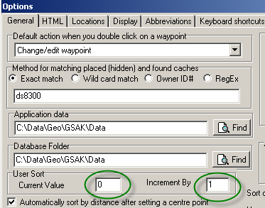
Start by setting the User Sort Current value to 0 and the Increment By value to 1.

GSAK Options page

GSAK Options page


Step 2
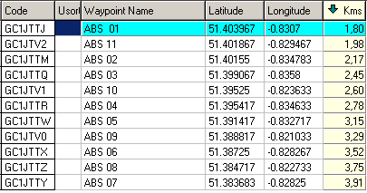
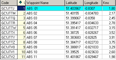
Filter out the caches on the track you want to follow and manually add the sort order by double clicking in the cell one at a time in the order you want them sorted. In this example, from near to Wokingham, the order of the waypoints is sorted by distance from my centre point location. Obviously, in a real case you won’t show the distance column.
Filtered GSAK list

Filtered GSAK list for a track


Sorted GSAK list

Filtered and sorted GSAK list


The result is roughly what was achieved in the Excel example shown in GeoCass blog.

Step 2a (optional)
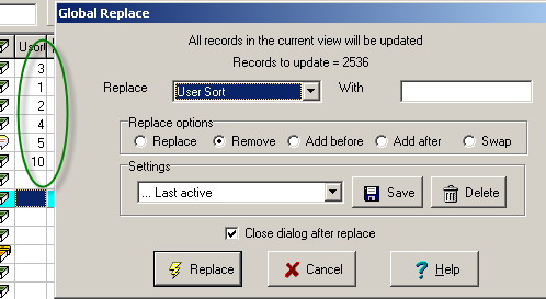
If you make a mistake when using the User Sort you can purge the listing by doing a Global Replace. You will find this in the Database menu. Replace User Sort with “blank field”. That will clear the list and you can then go back to step 1 and reset the counters. It’s good practice to do this every time after extracting your track waypoints.

Global Replace

Global Replace in GSAK


Step 3
Export as a CSV file and continue to manipulate it in Excel as described. The final result on http://maps.the-hug.net/index.php looks good but unfortunately for me it only works in the UK. Good for those geocaching trips I make there though! 🙂

ABS Track on OS Map

What would be really great (and a challenge for a GSAK macro designer) is to get a macro in GSAK to do this.
-Filter out columns manually?
-Sort manually?
-Concatenate each line to get the needed XML format
-Add some XML preamble text
-Create and save a text file

The Google Maps API could be the next stage of development. I started playing with it but don’t have the time or skills to get it working really well. A simple use is seen here ds8300.com/Maps


Some GSAK statistics

7 06 2010

As with so many other geocachers, I find GSAK an invaluable tool to support me in my geocaching activities. It’s “not just about the numbers”. Well, actually it is, but not necessarily just going for the largest number of finds. I find it more challenging to work with the stats related to geocaching – how many finds in a month, How many caches I have found in each county in England, how many of difficulty 3 and terrain 2 and so-on. The possibilities are endless.
One thing that I track is the caches I have found per difficulty and terrain rating. See my blog The goal there is quite clear: find all 81 combinations! Other figures I follow are the number of dates in a year that I have found caches. Until recently I have not actually found caches on every date in a month (They don’t all have to be in the same year to qualify), so now I am really pleased to see that I have found caches on all the dates in May. Yippee!

Caches found on every day of May

The picture above is generated from GSAK by the previously reported macro that is available from the GSAK forum, which generates all manner of statistics and is the basis for what I have in my geocaching profile. What I like best is the picture of the world that shows where I have been caching, but that’s another blog…


Down under!

22 05 2010

What do you do when you have 24 hours flying time between Stockholm and Sydney? The flight from Stockholm to Bankgok was on an old Boeing 747 without individual screens so there were few distractions once the dinner had been eaten. Of course, I used the time to prepare for my caching in Sydney which will not be as advanced as it may seem due to time limitations. I have this Sunday and next Saturday to hunt for those micros and nanos that Sydney has to offer in the CBD. I will see how many finds I can add to the twelve that I presently have in the city, I also started going through some of the caches I have logged in GSAK in order to add a few lines to the “Special” section in the FindStatsGen macro as there has never been time before to decide which caches could be placed in that section. By the time I got to Bankgok the battery had given up on the PC and finding a power outlet at Bangkok airport was impossible so I spent the flight on the Airbus 340 between Bangkok and Sydney watching the multitude of films and TV shows on the personal screens.

Being of a somewhat structured nature I keep a database of my flights and I can see that this is flight 1665 and somehow that seems to be rather a large number. An even larger number is the total distance I have flown and that turns out to be a whopping 3,274,578 km or 79.25 times round the world. Phew! So how far have I travelled whilst geocaching? I wondered. The GSAK stats macro gave me the answer as being 506,562km or 12.26 times round the world. Not bad eh? The 1900+ caches I have found have been spread over 21 countries which is probably not a record but it is still something I am proud of achieving.

Got to Sydney, swished through immigration then got stuck waiting for my suitcase at the baggage claim. Why does my bag always have to come last or nearly last? Infuriating! I got even more irritated when I hit customs because even though I had nothing to declare I got sent to the red channel and got stuck behind a group of Chinese with enough food in their luggage to last a month. The thing to know about Australia is that the laws are very strict on what foodstuffs and other organic materials can be brought into the country, pretty much as they are in USA. Having seen what the Chinese group had with them I can see the reason for the rules. Anyone for fermented cows intestines?

Once through customs I found the company driver waiting to whisk me to my hotel (it’s nice to have some perks) where I had a shower and finished this blog sipping a cold amber one!


GSAK and FindStatGen3.9beta

20 05 2010

My geocaching tool of choice is GSAK and I am very satisfied with it as the all-encompassing tool for managing information on my geocaching finds and hides. Some of the information generated for presentation in HTML format is entertaining. This is handled very well by the macro “FindStatGen3.9beta” by Lignumaqua (my kudos to him and Rutson who I believe was one of the persons behind the first macro for generating statistics from GSAK). Some of it makes me wonder if there is some error in my reasoning or a calculation in the macro for generating statistics that doesn’t agree with what would seem to be a more likely answer.

Click on image to enlarge.

In my simple world the centroid of the caches that I have found should lie within the coordinates given. The northing lies above the most northerly cache and that does seem rather odd. I will post this on the GSAK forum and see what the response is.

One of my goals for 2010 is to fill in another 10 squares in the Difficulty / Terrain matrix. I have been able to add a D5/T2 since I decided on my goal so the situation is now. 51 combinations found out of 81 possible. Of course, they are nearly all at the high end of the scale. The new way that they are presented from the GSAK data is an improvement on the earlier output, but it still lets me see how many white squares I have to fill.

Click on image to enlarge.